Keon Monroe

Geospatial Developer & Technologist

  • HOME
  • BROWSE
  • ARCHIVES
  • ABOUT
Home
3D terrain visualization of mountain landscape rendered with rayshader

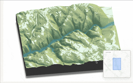
Shiny 3D Terrain - Interactive Rayshader Visualization

Shiny 3D Terrain is an interactive R Shiny application for generating 3D terrain visualizations using the rayshader package. Select from preset locations across the US or draw custom areas to rende...

Jan 16, 2026
Population Density Map with PyDeck & DuckDB

30 Days of Maps Challenge (2025)

A curated selection of interactive maps created for 30DayMapChallenge 2025, focusing on modern open-source geospatial tools and web-based visualization. The challenge is an annual data visualiza...

Oct 31, 2025
ArcGIS JavaScript Maps Collection Screenshot

ArcGIS JavaScript Maps - Interactive Web Mapping Collection

A collection of maps built with the ArcGIS JavaScript SDK and Calcite Design System. Project Overview Recently I completed the ESRI Training course Getting Started with ArcGIS Maps SDK for Java...

May 31, 2025
StreamGit Analytics Dashboard Screenshot

StreamGit - GitHub Analytics Dashboard & CLI Tool

StreamGit uses Streamlit and the GitHub API (via PyGithub) to provide a comprehensive analytics app and CLI tool for analyzing and managing your GitHub repositories. Project Overview StreamGit ...

Nov 14, 2024
Map the Vote 2024 Electoral College Interactive Map

Map the Vote 2024

Map the Vote is an interactive web application that allows users to explore and visualize different scenarios for the 2024 U.S. Electoral College map. The project was inspired by the FiveThirtyE...

Oct 19, 2024
Philadelphia Steamloop Map

Streamlit Folium Map of Philadelphia's Steamloop

This interactive data visualization uses Streamlit and Streamlit-Folium to generate a mapping dashboard of the Philadelphia steamloop. Check out the app here, hosted on Railway. The dashboard a...

Feb 1, 2024

30 Days of Maps Challenge (2023)

A series of maps created for 30DayMapChallenge, a daily social mapping project happening every November. The 30 Day Map Challenge is a annual data vizualization challenge encouraging professiona...

Oct 31, 2023
FOSS4GNA 2023 Baltimore

FOSS4G NA 2023 Recap: Exploring Open Source Geospatial Tools

Last October, I had the privilege of attending the FOSS4G (Free and Open Source Software for Geospatial) North America 2023 conference in Baltimore. It was an enlightening experience that show...

Aug 24, 2023
Philadelphia Permit Predictions

P3: Philadelphia Permitting Predictions

A predictive model written in R for Philadelphia’s zoning and permitting data. It aims to predict the number of future permits issued in a given month based on historical data. This project was co...

Dec 19, 2019
Motus Research Collaboration

Motus Radio Telemetry Wildlife Tracking - Capstone Project

Using the Motus wildlife tracking system, I studied how birds perform after surviving window collisions during migration. This research, conducted in collaboration with Powdermill Nature Reserve an...

Dec 9, 2019

Trending Tags

project visualization mapping web-dev academic cartography gis open-source python 3d

A new version of content is available.